Wayfinding in West Sacramento
Project Background
In June 2018, WALKSacramento and the City of West Sacramento launched a first-of-its kind school-based active transportation wayfinding pilot program. The program leveraged existing Safe Routes to School efforts to encourage families to walk or bike from school to other parts of the community and provide feedback on their trips to inform future iterations of the wayfinding program.
Since the launch of the program, the City of West Sacramento has been awarded funding by the Yolo-Solano Air Quality Management District to permanently install wayfinding signs that focus on walking and biking.
Project Role
Consultant
Project Partners
City of West Sacramento
Project Funding
Caltrans Safe Routes to School
SACOG TDM
Project Timeline
June 2018 – November 2018
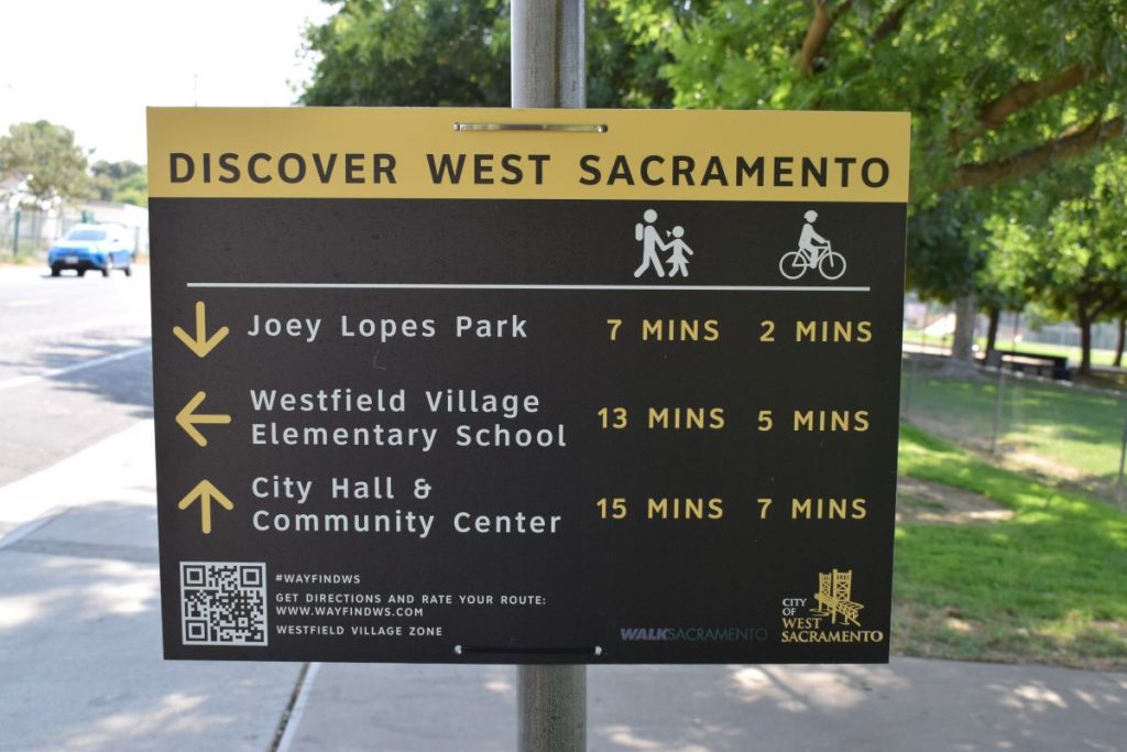
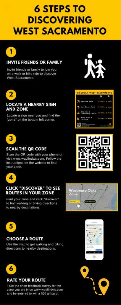
What is wayfinding?
Wayfinding is a signage system to help people orient themselves in a space. Signage uses visual cues to direct people from point A to point B or highlight points of interest. Good wayfinding systems are intuitive with clear and concise messaging, shows only information that is relevant to the space, location, or navigation path, uses graphics effectively and efficiently, and does not include excessive information that may confuse the audience. Wayfinding programs can be temporary or permanent and are a perfect way to encourage people to explore your community in a new way.
Project Goal
The goal of the program was to help residents and visitors make decisions about their travel behaviors to reduce vehicle miles traveled (VMT) and increase bicycle and pedestrian mode share. Furthermore, the program encouraged families to visit community destinations in West Sacramento by foot and/or bicycle, exposing students and parents to alternative modes as viable transportation options rather than just for recreation. Finally, the program was intended to highlight key community destinations and pilot an active transportation wayfinding approach with opportunities for user feedback in order to inform future, more permanent wayfinding programs as well as community-identified infrastructure improvements.
Pre-Program Surveying and Methodology
The signage system built upon work already underway to encourage more walking and biking to school. West Sacramento is a community with many families, and as such, the pilot program used school sites as hubs from which to direct users to other parts of the community. Community surveys were distributed to identify popular destinations within a one-mile radius of schools for walking and biking. Respondents requested community amenities such as parks, trails, community centers, and local businesses be highlighted on the signs. Respondents also indicated that they were willing to walk up to one mile or bike up to three miles to a destination in ideal conditions.
Thirty-four destinations were identified based on the survey findings, with thirty locations for sign placement. In some cases, routes to farther, high-profile destinations such as Raley Field and City Hall were included as a city-wide connection.
Project Outcomes
The wayfinding program with the City of West Sacramento was the first of its kind to be implemented at the school-district level in the Sacramento Region. The project supported implementation of the City of West Sacramento’s Bicycle, Pedestrian, and Trails Master Plan which includes active transportation focused wayfinding as an action item. Additionally, the project supported the roll out of the regional bike share system and the City of West Sacramento’s micro-transit pilot. While it is difficult to evaluate the effect of wayfinding programs on VMT reductions, resident feedback indicated that they can be an effective tool for education and encouragement around use of alternative modes that support larger mode shift goals at the community level.
Since the launch of the program, the City of West Sacramento has been awarded funding by the Yolo-Solano Air Quality Management District to permanently install wayfinding signs that focus on walking and biking. Neighboring cities in the Sacramento Region have also inquired about developing active-transportation focused wayfinding programs in their own communities.
The positive reception of the system and feedback provided by the community indicated that additional, low-stress pedestrian and bicycle connections throughout the City are desired and would encourage mode shift to active transportation modes for recreation and leisure trips.